
Global Ionospheric (TEC) Maps
GPS users with single-frequency receivers need ionospheric electron content information in order to achieve positioning accuracy similar to dual-frequency receivers. The GDGPS System provides a global real-time maps of ionospheric electron content (currently producing a map every 5 minutes). These maps are also of value in monitoring the effect of the ionosphere on radio signals, power grids, and on space weather.
The maps are derived using data from ~200 real-time GDGPS tracking sites, augmented with additional sites that are available on a 15-min and hourly basis. This probes the ionosphere with high spatial and temporal resolution. The integrated electron density data along each receiver-GPS satellite link is processed through a Kalman filter in a sun-fixed frame, to produce the global gridded maps of TEC. Movies are archieved and may be access at https://sideshow.jpl.nasa.gov/pub/usrs/rfm/nrtgim/
The maps are available redundantly from multiple GDGPS Operations Centers (GOCs) as images and IONEX files containing the gridded TEC values.
TEC values from these maps are used to correct the ionospheric delay, in arbitrary geographic locations, for the Virtual Reference Site (VRS) data product of the GDGPS System.
The JPL-GIM algorithm and products: multi-GNSS high-rate global mapping of total electron content", Springer, Journal of Geodesy. DOI 10.1007/s00190-024-01860-3. https://rdcu.be/ei3pD
Sample TEC Map
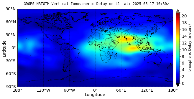
Click image to view full-size TEC map